
SYNERGISTIC EDGES, Landscape Design for a Coastal River : The Case of Cooum River,Chennai

Project idea
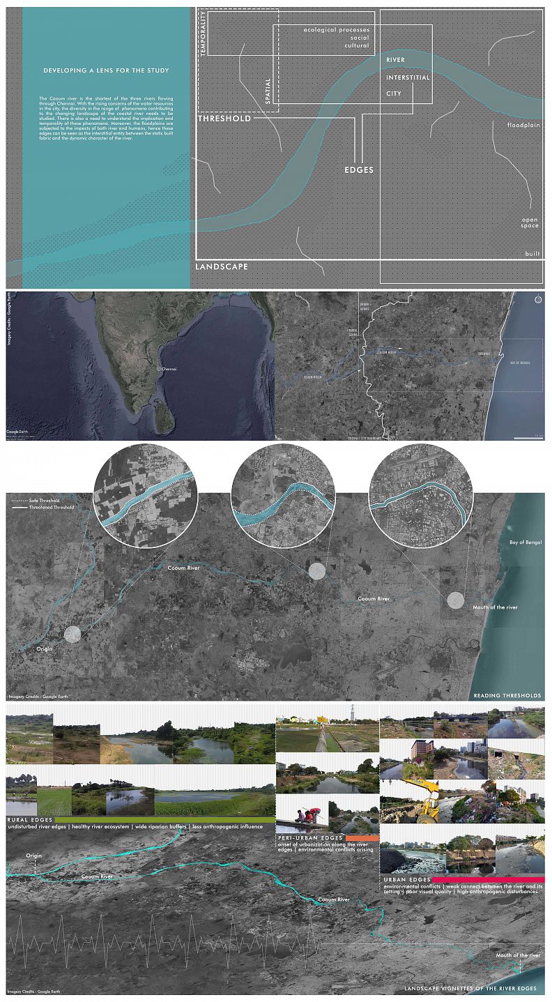
Chennai was on the global news for reaching its water thresholds. The crisis in Chennai has been a wakeup call for not only the citizens of Chennai but to the entire world. Urban coastal river systems are subjected to the pressure of the growing city as well as climate change. But is it fair to blame climate change when the anthropogenic reasons for the disasters haven’t been addressed? The landscape of a city and the characteristics of the river edges undergo a parallel natural and human-induced phenomena. In such a case, the thin line of caution is often breached causing catastrophic impacts. Such is the case of the River Cooum, which flows through the dense central parts of the city. Studies show that the river's ecosystem has been compromised due to several anthropogenic activities and years of neglect.
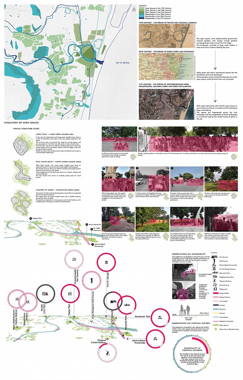
The open spaces in Chennai have evolved in their typologies from the colonial period and the ever-changing needs have a dynamic character to it. There is a need for establishing a ‘synergistic’ connect with the river ecosystem, places of historical value, and the edges can be seen as interstitial traversing through this dynamic character.
This thesis is based on the idea of establishing synergistic river edges that contribute to the improvement of the river ecology as well as offer a green realm for the community to experience, so that both entities, man and nature reap benefits from the interaction.
Riverfront open spaces need to be looked at beyond its recreational value. They could serve as an interstitial not just spatially but as a state of the human mind where you experience the realities and the possibilities of life as an enriching experience. They could also be seen as an extension of learning or working space, spaces for exploration, and cultural development. If they can be made accessible for all and at all times, there is so much that river can offer.
In a city that anticipates monsoon with the fear of destruction and damage. I believe the seasonality of these urban issues needs to be understood so that the design responds to it and hence bringing about the sense of a safe haven through the spatial construct of the open spaces. The intrinsic nature of the river to flow freely shall be understood by the people through the experience offered by the open space, in a way that demonstrates the idea of celebrating a river both visually and experientially.
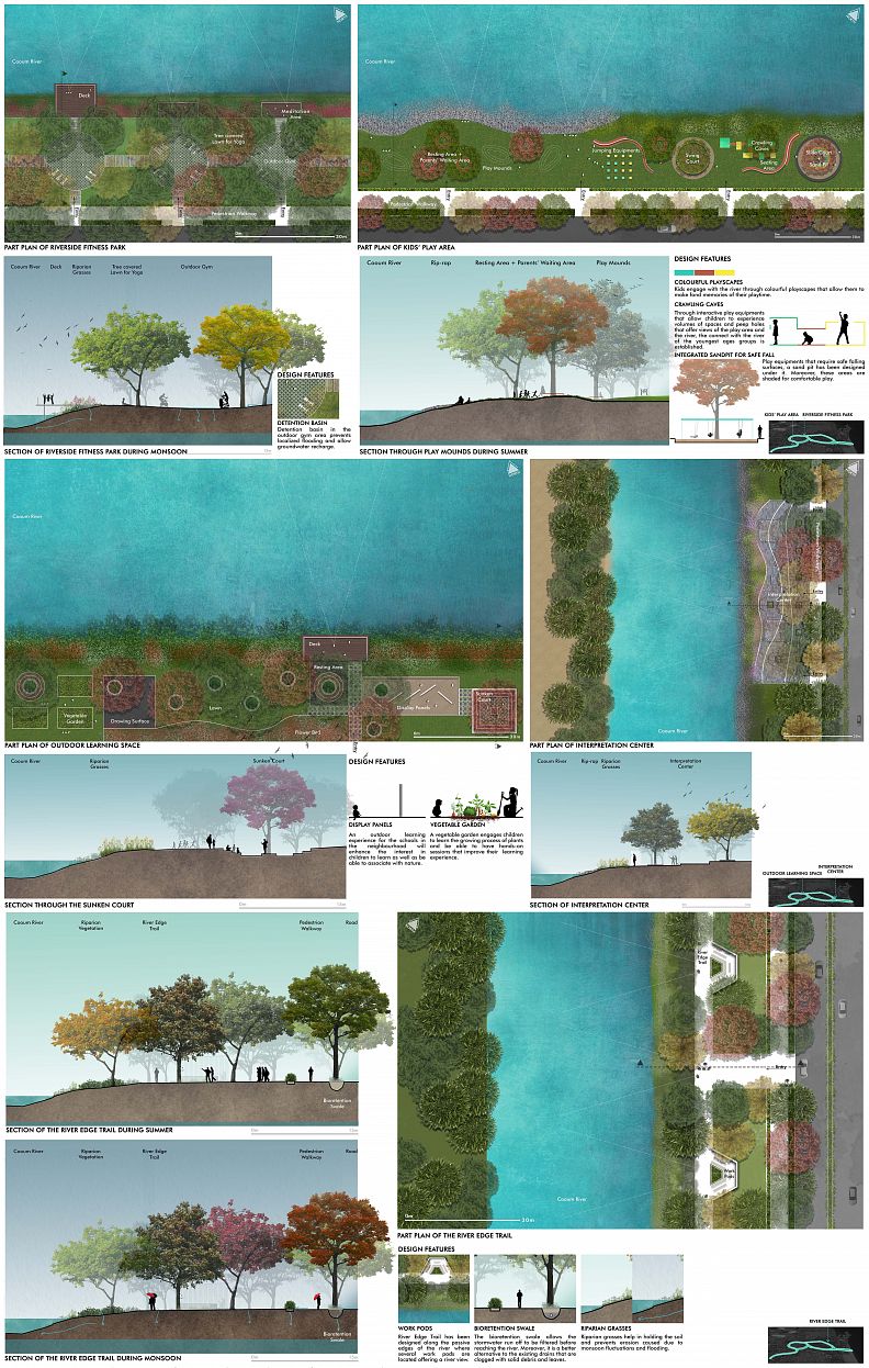
Project description
To enhance the open space experience along the river through shaded walkways linking places of historical value and the existing open spaces. The activity programme shall include opportunities for active and passive recreation, learning, exploring and establishing a synergistic connect with the river. The intrinsic nature of the river to flow freely needs to be respected. And a river has enough potential to widen its course if needed. The only thing is to provide sufficient riparian buffers that shall accommodate these changes.
The design is intended to respond to seasonal changes as well as the larger scheme of climatic changes. It shall contribute to the urban green cover, have ample surfaces for ground water recharge, manage stormwater runoff from the adjacent road networks, reduce the impacts of urban flooding due to poor urban drainage and filter the runoff entering the river.
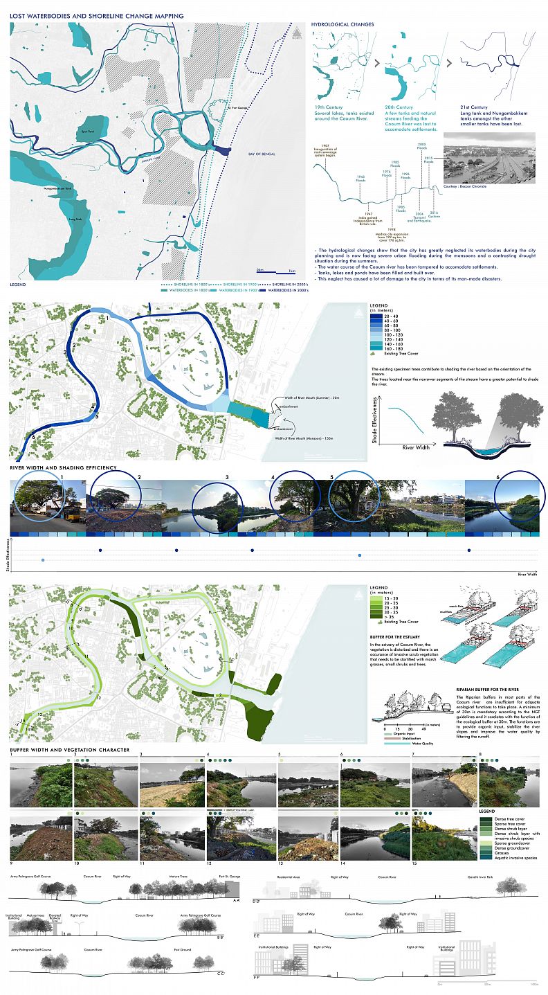
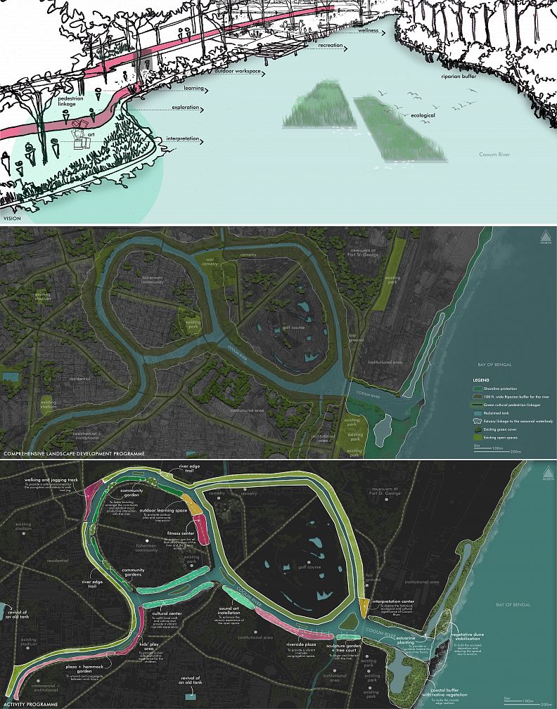
The Comprehensive Landscape Development Programme is focused on establishing the required coastal and river buffers that will be vegetated for coastal protection and riparian health respectively.
The lost stream of the river is reclaimed and so are the tanks which was part of the river landscape in the earlier years.
Linkages are oriented to create a favorable pedestrian experience along the river and the other open spaces and monuments of historical value.
The activity programme aims at connecting people with the river from the approach of being able to explore, learn and linger. Land-use and the user groups are considered while locating each of these programmes to ensure maximum usability of the space that intends to create a feel of wilderness.
Technical information
The thesis is a study-based design which included the following :
1. Developing a lens for the study
2. Mapping landscape vignettes along the entire course of the river Cooum
3. Analyzing the threatened thresholds that informs site delineation
4. Studying the natural processes and anthropogenic effects on site
5. Studying edge conditions along the river
6. Spatial adjacencies with the river
7. Evolution of open space structure and typology
8. Study of surrounding open spaces and the nature of interaction in the space
9. Accessibility and footfall mapping
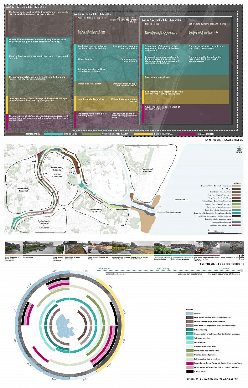
10. Synthesis based on scale of issues
11. Spatial mapping of the micro-level issues along the river edges
12. Synthesis based on seasonality of issues
13. Developing a vision and concept
14. Comprehensive Landscape Development Programme
15. Activity Programme
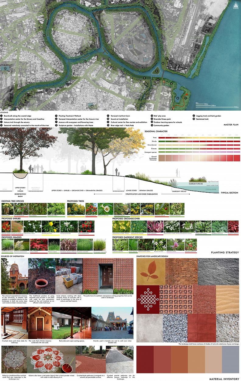
16. Master Plan
17. Material Inventory
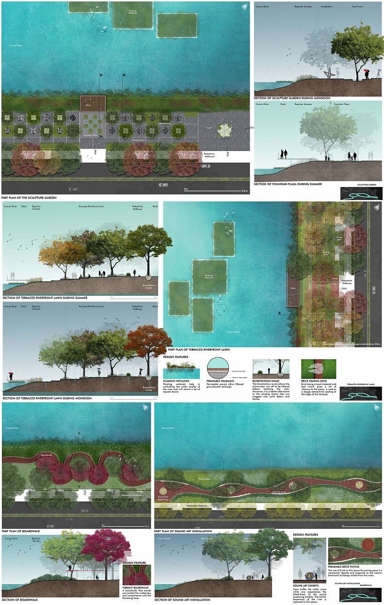
18. Part Plans and Sections
19. Planting Strategy
Co-authors
None.
Copyright © 2025 INSPIRELI | All rights reserved. Use of this website signifies your agreement to the Terms of Use, Privacy Policy, and use of cookies.