A Breathable Habitat: Reimagining housing for a low-income community

Project idea
The concept was to convert a crammed community into a breathable domicile that alleviates the existing inhumane living conditions. An attempt to create and improve a high-density standard living for the existing low-income population in Duaripara, Dhaka. The design aim was to utilize facilities and features like the lake and canal to create an improved living. The present site consists of problems like squalor, lack of open spaces, and inadequate facilities for an ideal community living.
Densely packed row houses with were replaced with 2 to 3 storied establishments. This created a hierarchy of open spaces to counteract the total lack of open spaces before.
Project description
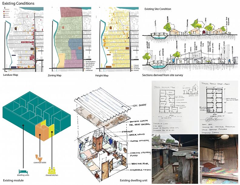
Existing Condition: The current population of Duaripara lives in below standard dwellings. Subpar living conditions within individual units were accompanied by a lack of community spaces and facilities.
The entire site had three types of residents that made up the user group:
• Bachelors living in mess houses (row houses made of brick with tin roofs).
• Tenants living in structures consisting of 8-10 rooms, each of which are occupied by single-families (4-5 people) (row houses made of brick with tin roofs).
• Landowners who have their individual houses. Only landowners have 2 storied pucca structures.
A portion of the site used to be dedicated for a local market in which both the community members and neighboring residents partake.
The main setbacks were:
• lack of breathing spaces resulting in the structures being cramped together
• no playing areas for children
• no community gathering spaces or facilities like parks and clinics
• dark and unhealthy living environment.
Designed Condition:
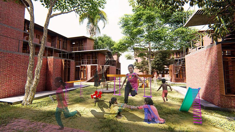
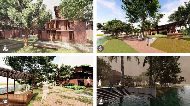
The primary concept of the design was to improve the living conditions of this low-income community by creating a hierarchy of open spaces. This was done by rising the dwellings to 2 to 3 storied units, which in turn reveals a large amount of open ground space.
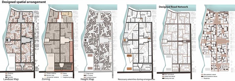
Zoning was first fixed by separating the zones for bachelor living spaces from the family living spaces for privacy. The landowners were allotted the lake-side plots adjacent to the road, to increase the land value.
A central open space was dedicated for the community to provide important neighborhood facilities like parks, clinics, NGO offices, mosque etc.
The market zoning was kept in its previous position as that is where the existing demand is generated.
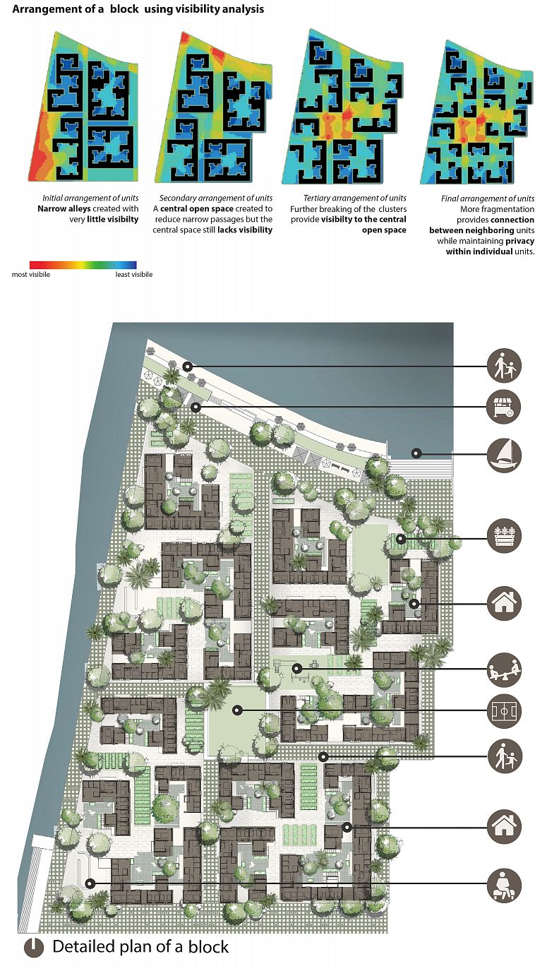
The area dedicated to residences was divided into 9 parts, each called a 'block', created by division or the road network.
1. Hierarchy of open spaces
The open spaces are created at five different type of area and cater to specific functions:
• Large central open spaces. These are created at the ends and intersection of the horizontal and vertical spines of the road network. There are 4 of these spaces and they provide necessary community services, amenities and dispersion space for emergency evacuation.
• Block wise openings. Located at the center of each of the ‘blocks’ and are used as playing grounds and central gardens.
• Corner crevices. Utilized as corner shops, pocket parks or vegetable gardens.
• Cluster courtyards. Open courtyard space within the cluster for their daily activities and socialization.
• Balconies. Balconies are created at each of the levels which not only reduces cost but also enforces the socialization required for peaceful living within this type of community.
Technical information
2. The masterplan
• The primary access gradually opens up to a large open central community space. This periphery of this space has amenities and services like clinics, NGO offices, training centers and such. This central community space is at the meeting point of the horizontal and vertical spine of the primary road network.
• The spine along E-W terminates at the mosque premises, which also provides scope for community gathering and has direct visual access of the central community space.
• Two other community spaces are provided, one beside the lake (where a primary school was also provided) and another within the bachelor quarters.
• The primary road along N-S splits into secondary roads that form pinwheel organization stemming from communal spaces.
A local corner shop was placed within every block.
The positioning of schools, mosque and clinics along each of the edges forms a triangular network that allows for an efficient dispersal area in case of emergencies.
A large ‘ghat’ (stairs or a passage leading down to a river) was introduced at the center of the edge of the lake. The ghat would not only work as a station for boat (নৌকা) rides but also functions as a serene siting and relaxation area. The waterbody was also revived to its original state by connecting the lake to the stream.
3. Clusters
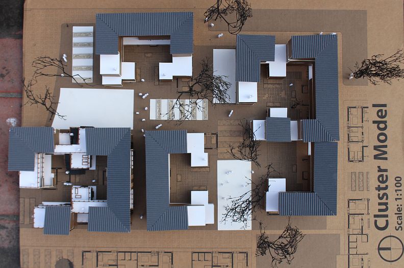
For tenants, a specific 'L' shaped basic module was created, consisting of 7 'units', one for each single-family, a kitchen, two toilets, and a shower room. Combinations of this basic module led to the formation of 4 types of clusters.
For landowners, a specific module was created consisting of 5 rooms, a kitchen, and two bathrooms.
For bachelors, row houses were created and positioned in two different orientations.
These clusters and modules were arranged to create the arrangement of open spaces with a central open space in the middle of each block.
Materials and Construction
•Locally available materials were used to reduce cost
•Bamboo “chatai” (local bamboo mats) were used under the roofing for passive cooling, reducing electrical costs
•External metal stairs are to be used to reduce construction costs
•Community members are encouraged to take part in the construction work to help build their locality as an additional source of income
Vegetation Plan
• Incorporate large fruit trees in road side and community opens spaces.
• Medium sized fruit trees in household areas.
• Useful plants like neem etc. near households.
• Herbs in terraces/kitchen extensions.
• Hierarchy of plantation- Ground covers, shrubs, medium trees, large trees.
